How about taking a walk in Kami Town?(9 areas, with coupon)
問い合わせ番号:16181-9629-7558
更新日:
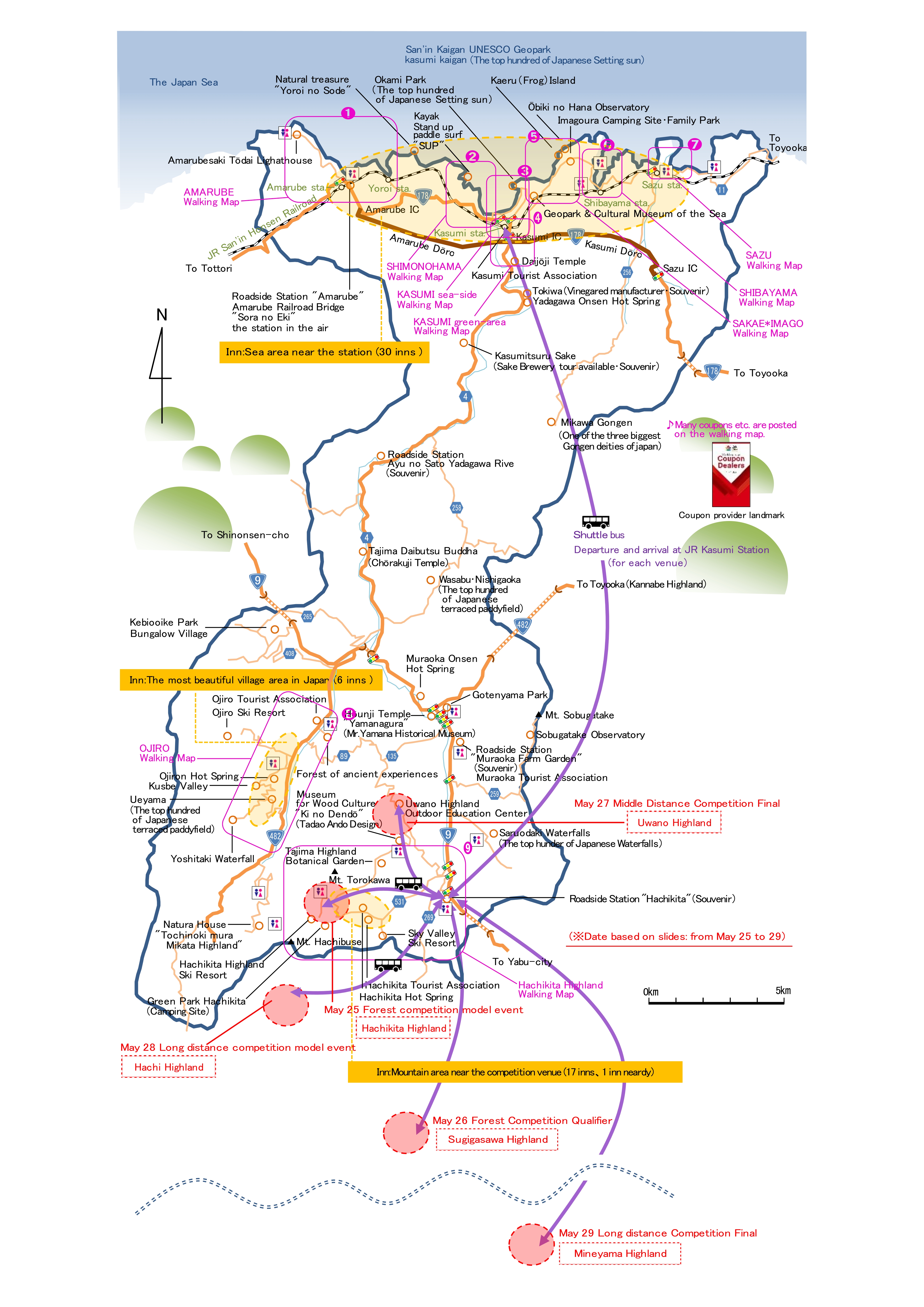
Kami Town Map (Location of each map)
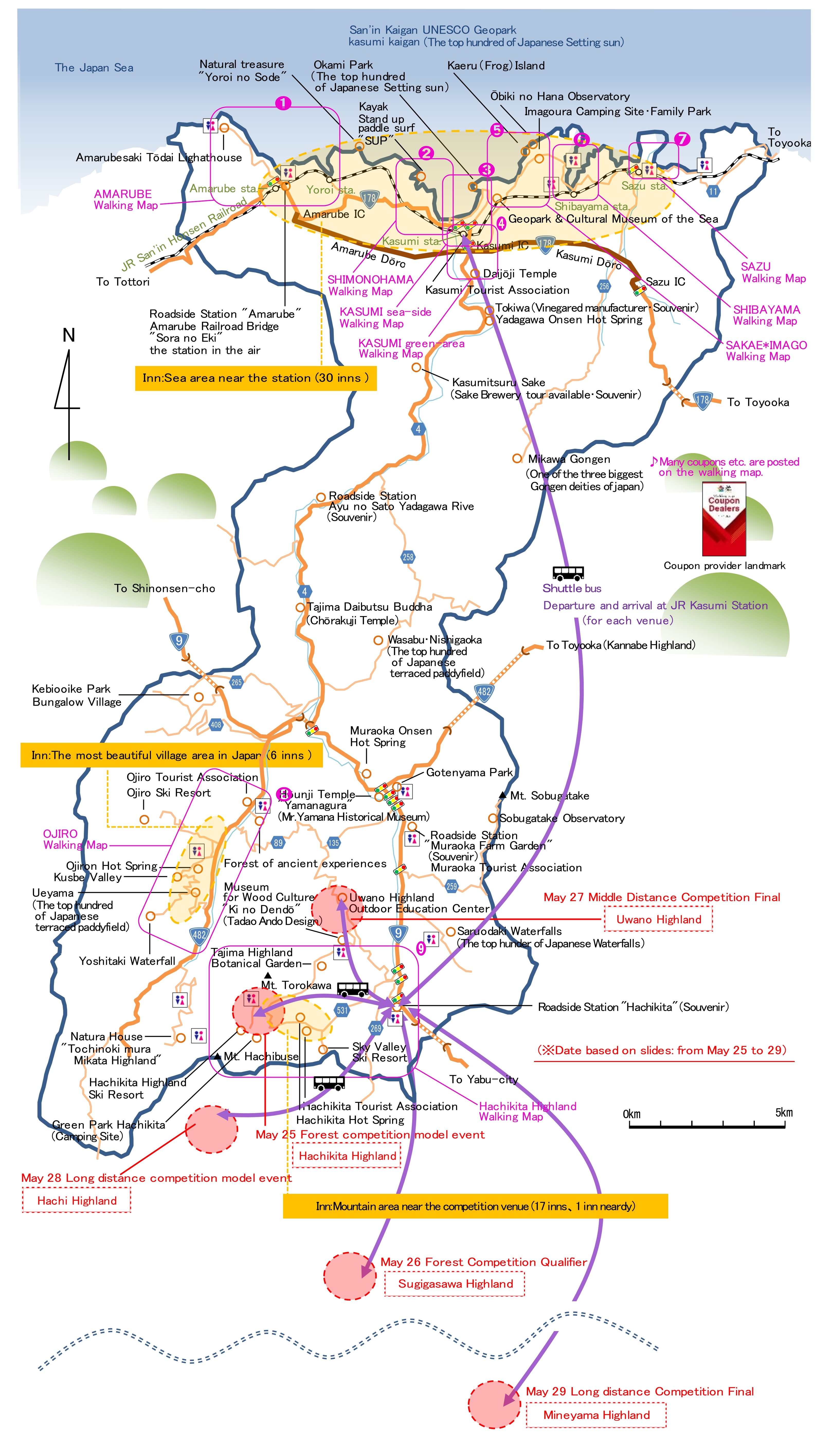
Enjoy town walks around temples and scenic spots, activities, such as kayaking, local food specialties, souvenirs, and more.
(With coupon) The map is divided into 9 areas in total.
Please note that the coupons will be available from 2022 in line with the World Masters Games, so please wait for a while.
※The coupon is for the World Masters Games 2021 Kansai, which will be held in 2022. It and will be revised to the 2027 edition.
Please wait a moment now.
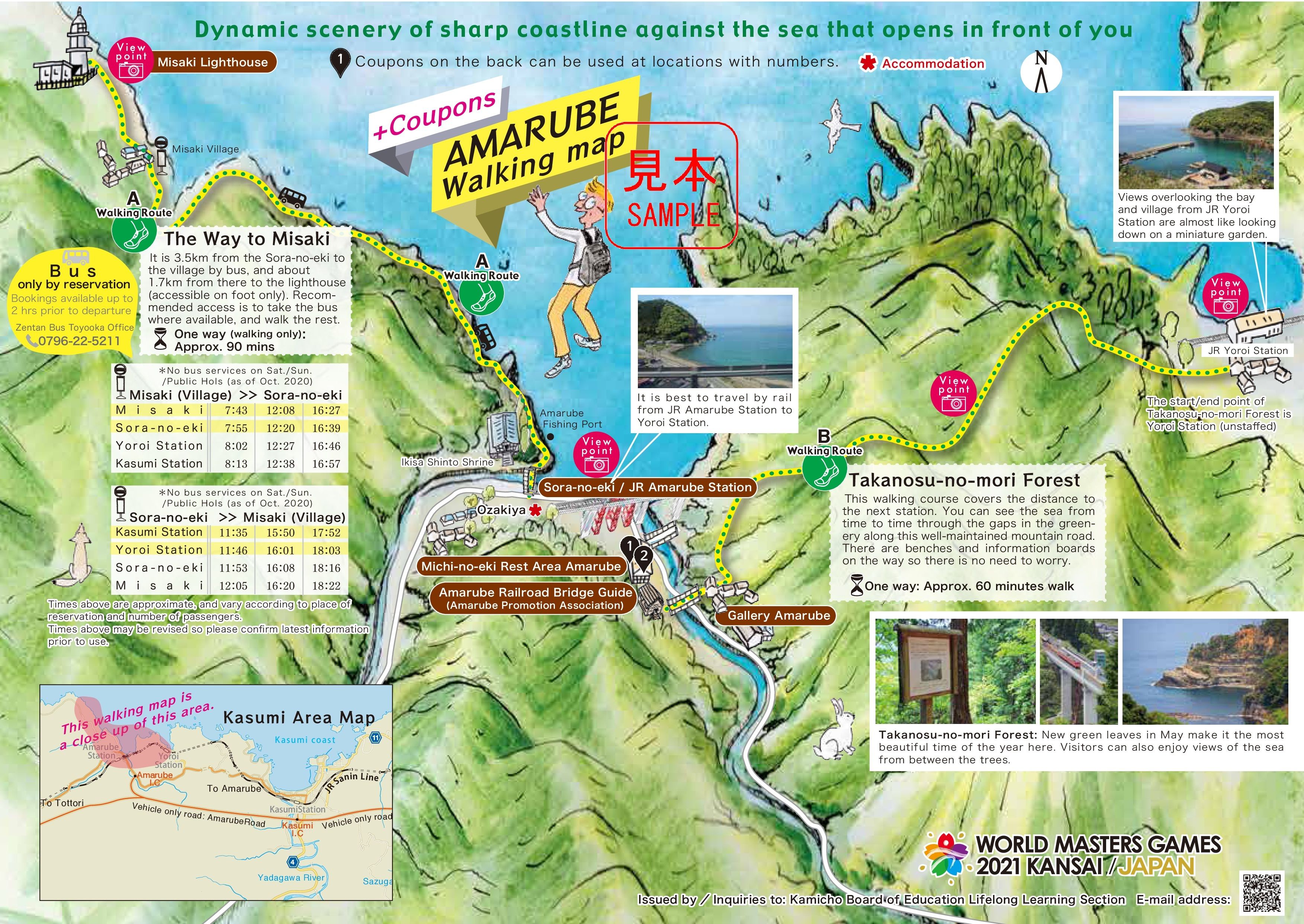
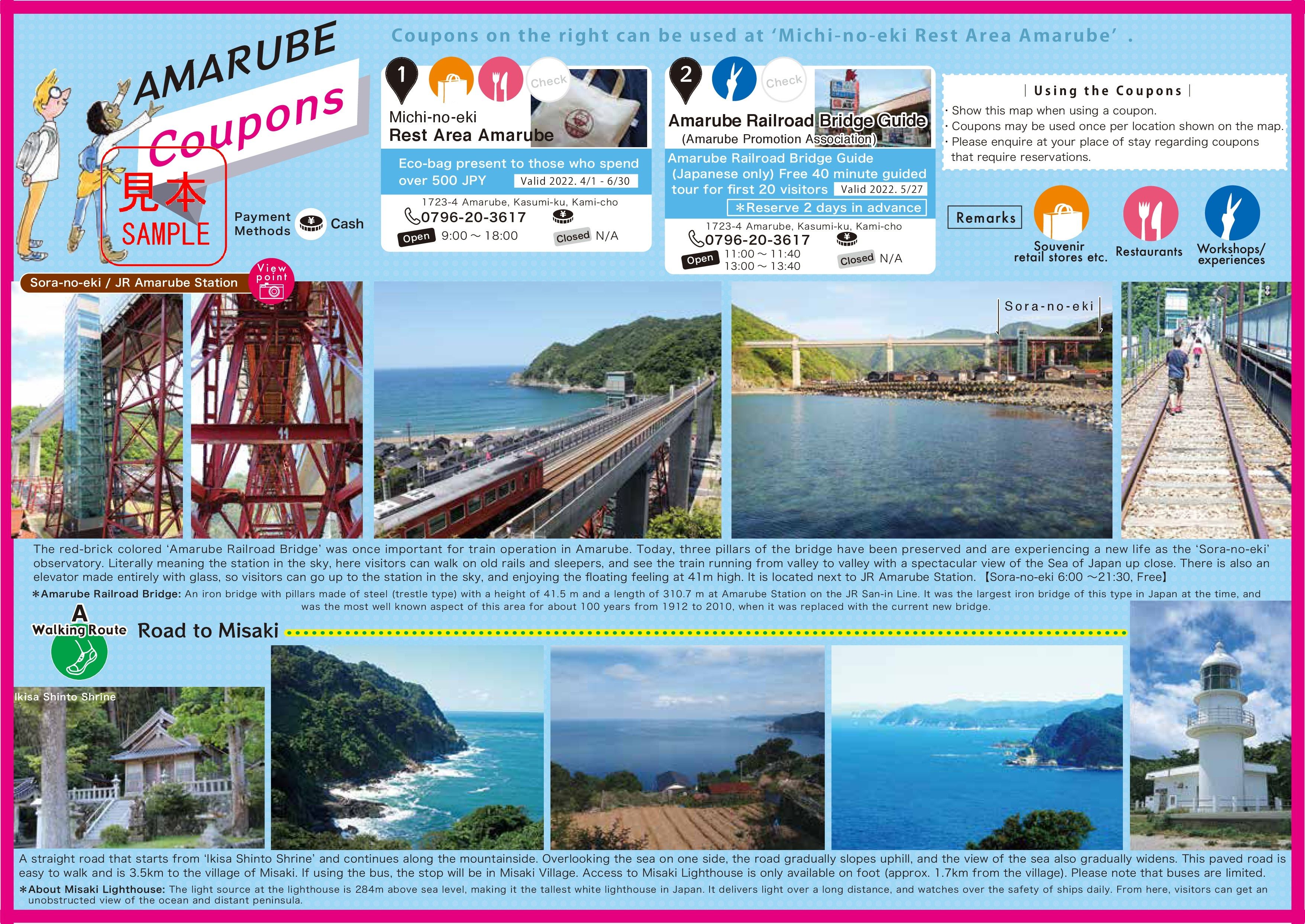
➊AMARUBE Walking Map
Recommended points
This is an introduction around JR Amarube Station area.
The red iron bridge, which was once Orient's largest iron bridge, has been preserved as "Bridge in the sky" a top three of it's original legs.
You can enjoy the view from 40 meters high, and walk on the original railroad tracks.
There is also the white "Amarubesaki Lighthouse", is technically Japan's highest white light house. It is approximately 5km from JR Amarube station.
Amarube Walking Map(Map)
Amarube Walking Map(Details of coupons and walking routes)
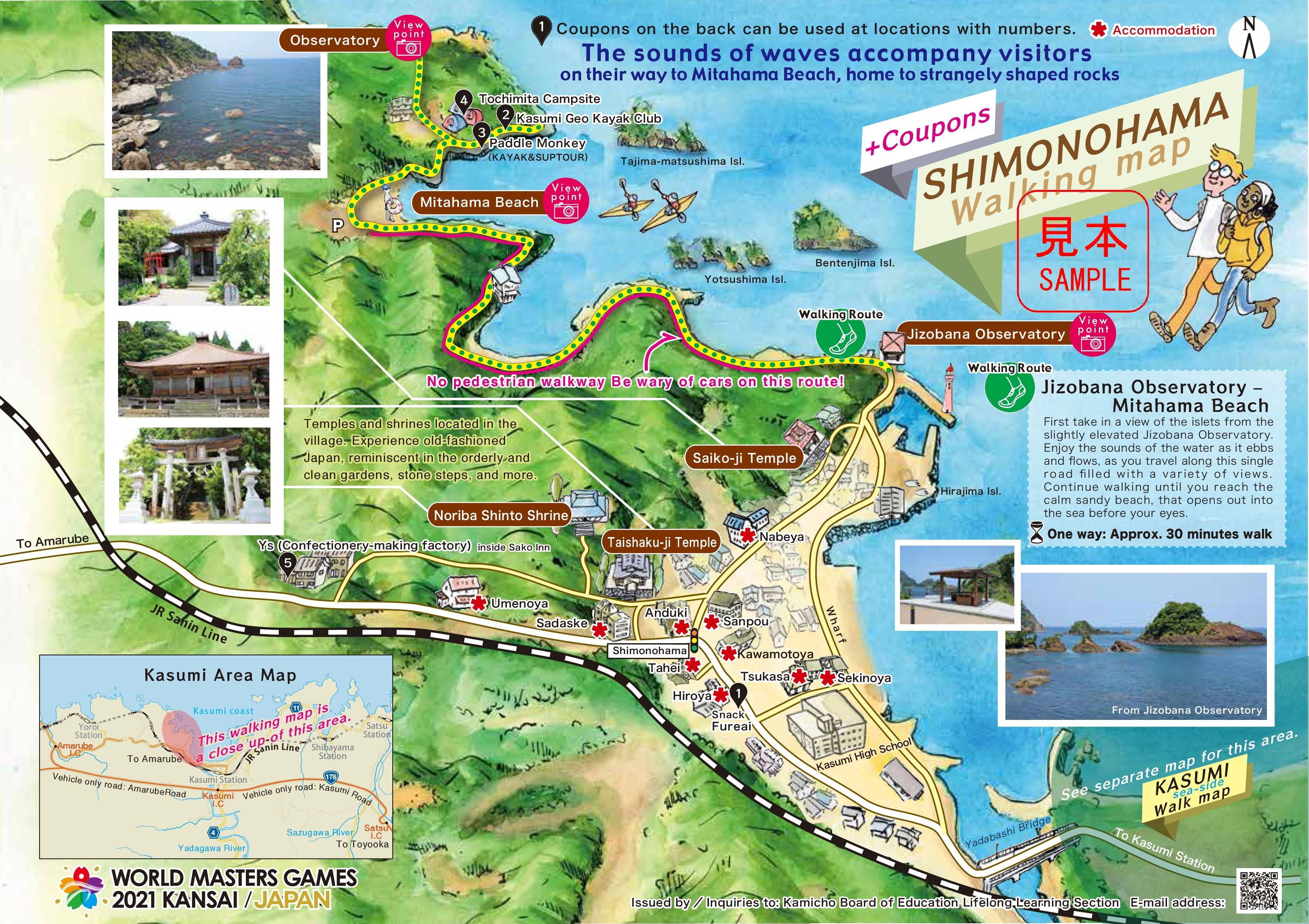
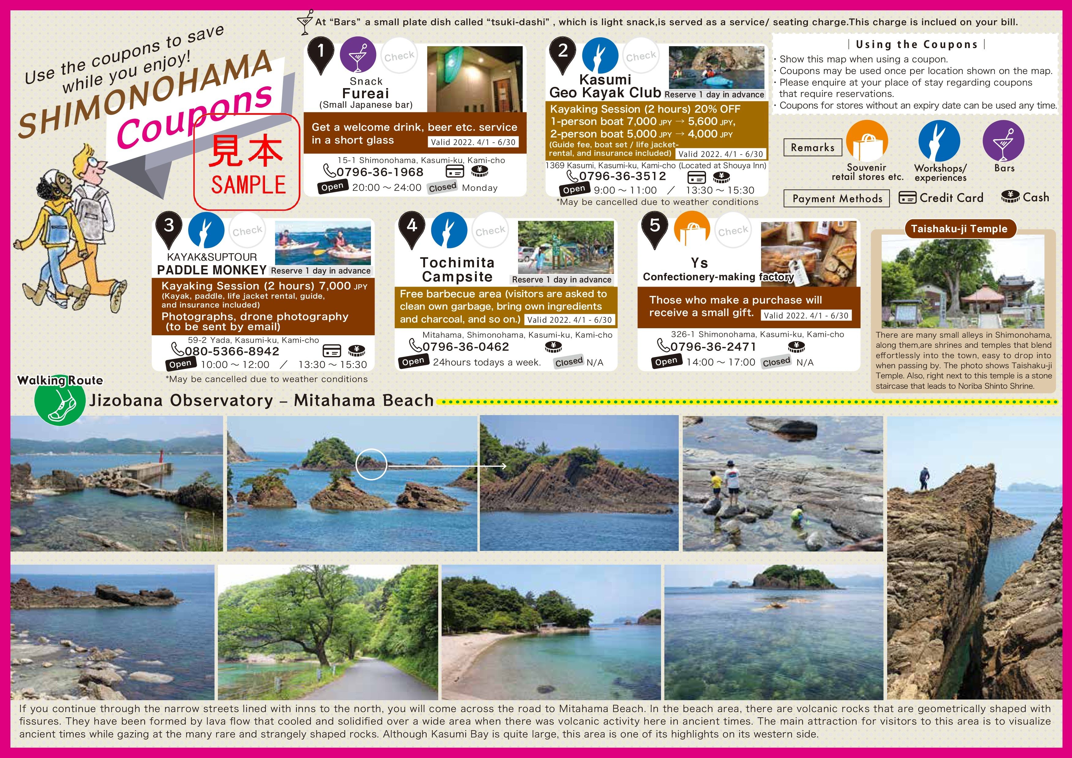
➋SHIMONOHAMA Walking Map
Recommended points
It is a map on the west side of JR Kasumi Station toward the sea. There are many accommodations.
You can see uniquely shaped rocks and islands of alog the winding coastline while you travel to Mitahama beach.
You can also enjoy sea kayaking and standup paddle boarding "SUP" at the beach.
Most of the accommodation have "onsen" hot spring baths where you can relax and recharge.
Shimonohama Walking Map(Map)
Shimonohama Walking Map(Details of coupons and walking routes)
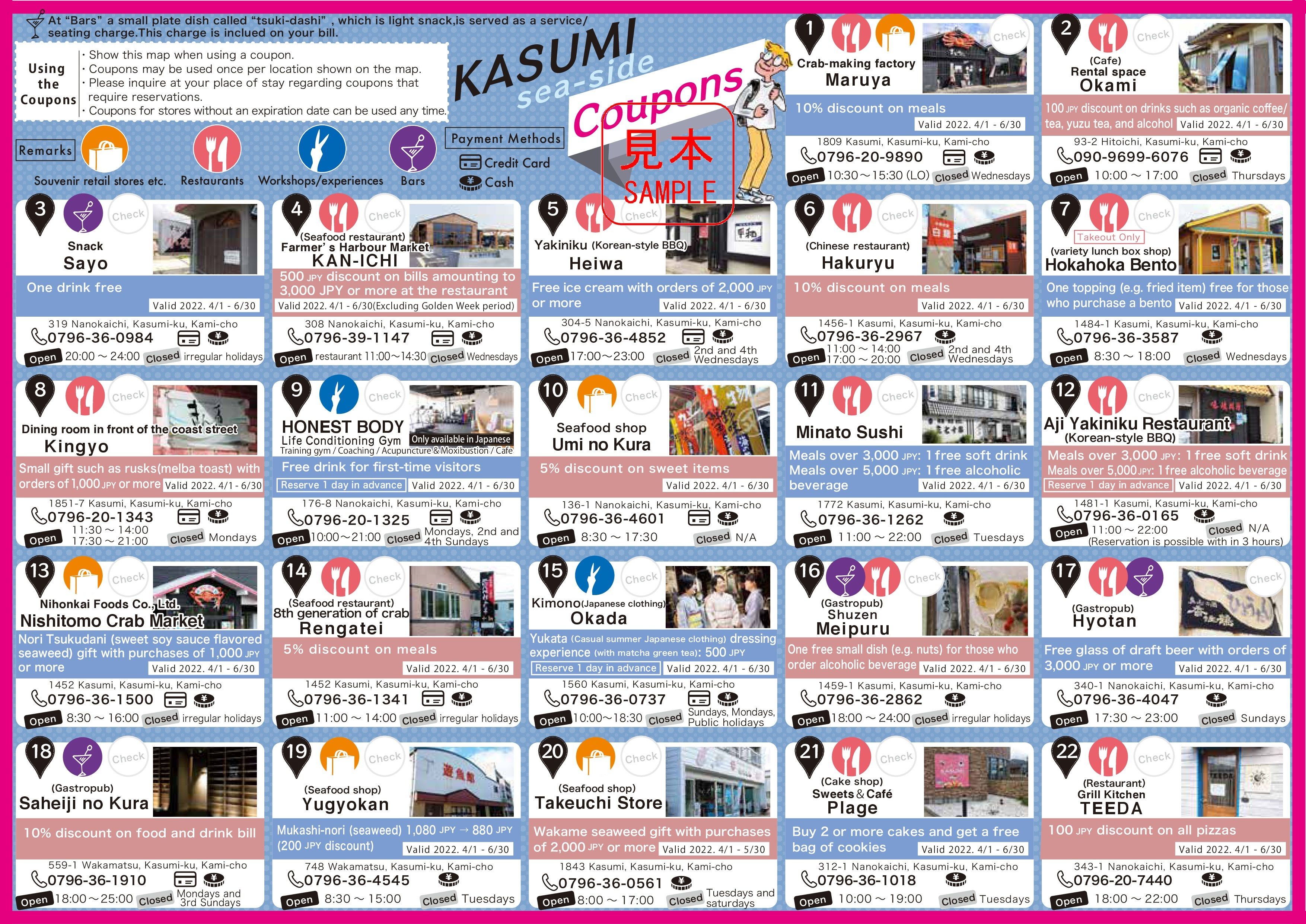
➌KASUMI Sea-side Walking Map
Recommended points
It is a map of the place near the sea around JR Kasumi Station.
There is "Shiokaze park" which is full of liberation is a recreational area near the kasumi hama beach.
There are many restaurants (grilled meat, sushi, bars, seafood souvenirs, sweets, etc.), and you can enjoy glamping and auto camping.
"Okami Park", is a cliffside sunset viewing spot on the Kasumi Coast, which was selected as one of the "100 best sunsets in Japan".
Kasumi Sea-side Walking Map(Map)
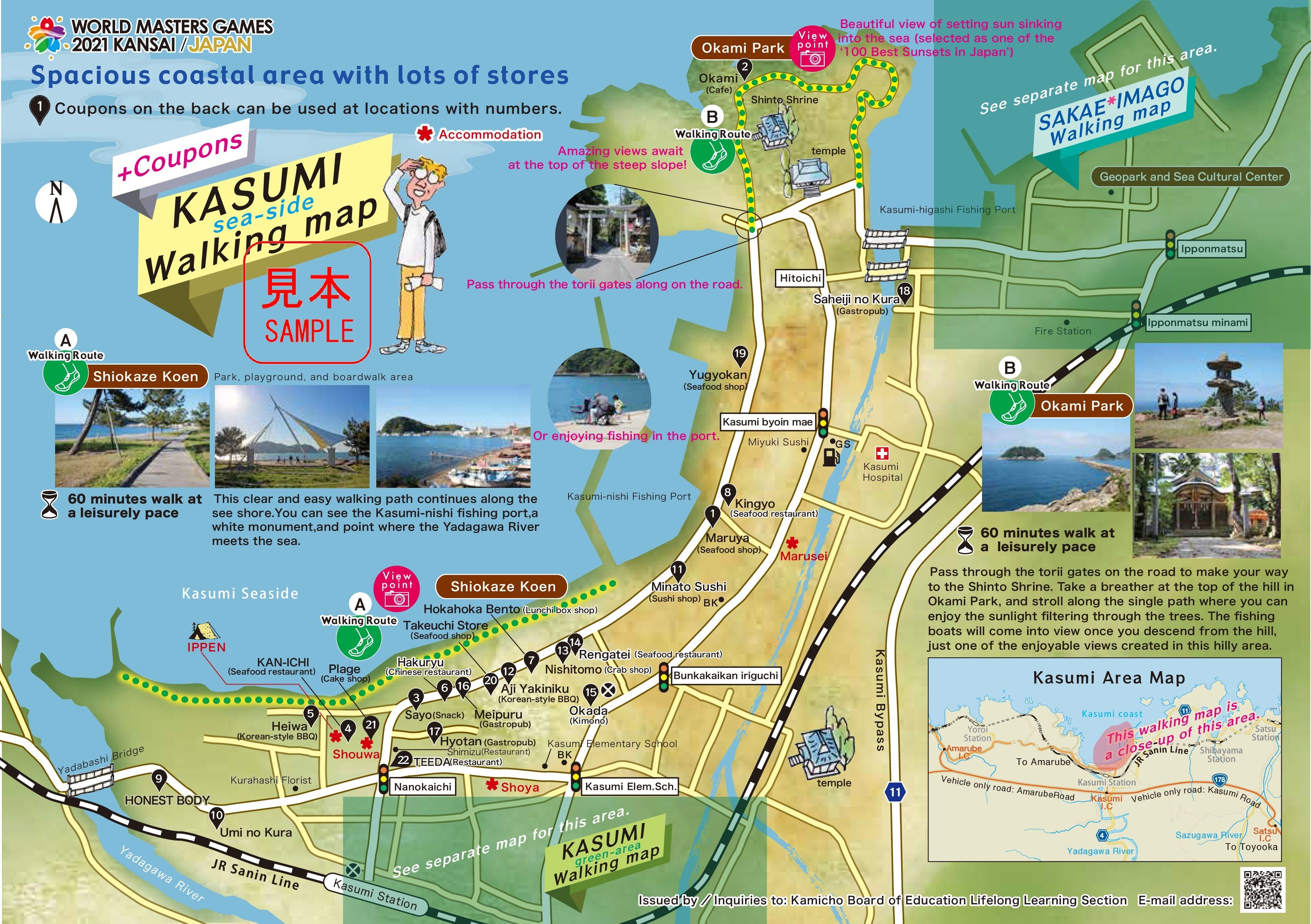
Kasumi Sea-side Walking Map(Coupon)
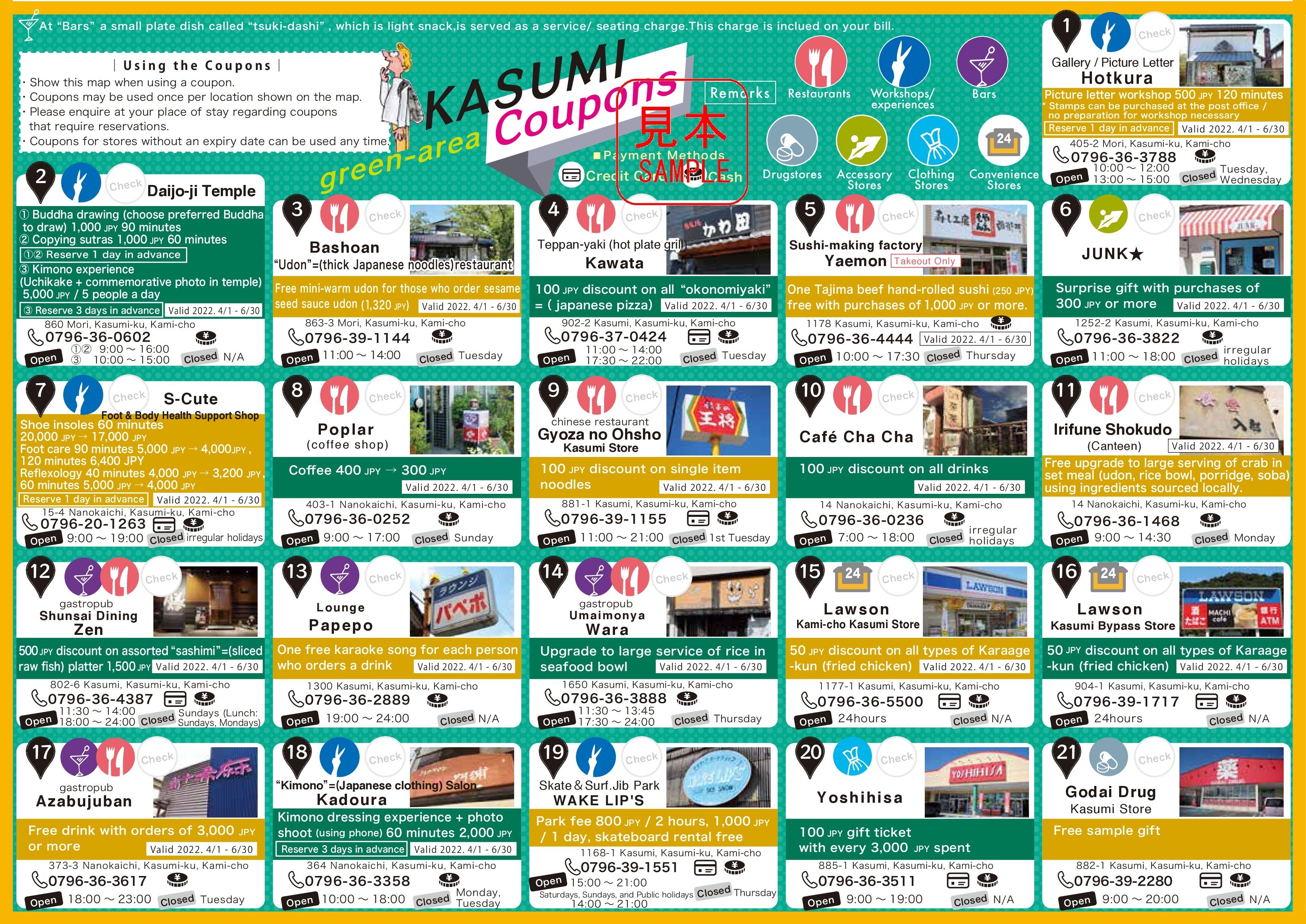
➍KASUMI Greenarea(Mountain side) Walking Map
Recommended points
This is a map of the mountain side around JR Kasumi Station.
"Daijoji temple" contains special sliding door "fusuma paintings" in each room drawn by the Japanese painter "Maruyama Okyo".
The entire temple is a museum.
In addition, there are many shops (restaurants, convenience stores, bars, clothing, pharmacies, etc.), and you can also make picture letters and experience wearing kimono, and there is also a skate park.
We recommend you to walk the country road to Daijoji while thinking about history and admiring the charming precincts.
Kasumi Greenarea(Mountain side) Walking Map(Map)
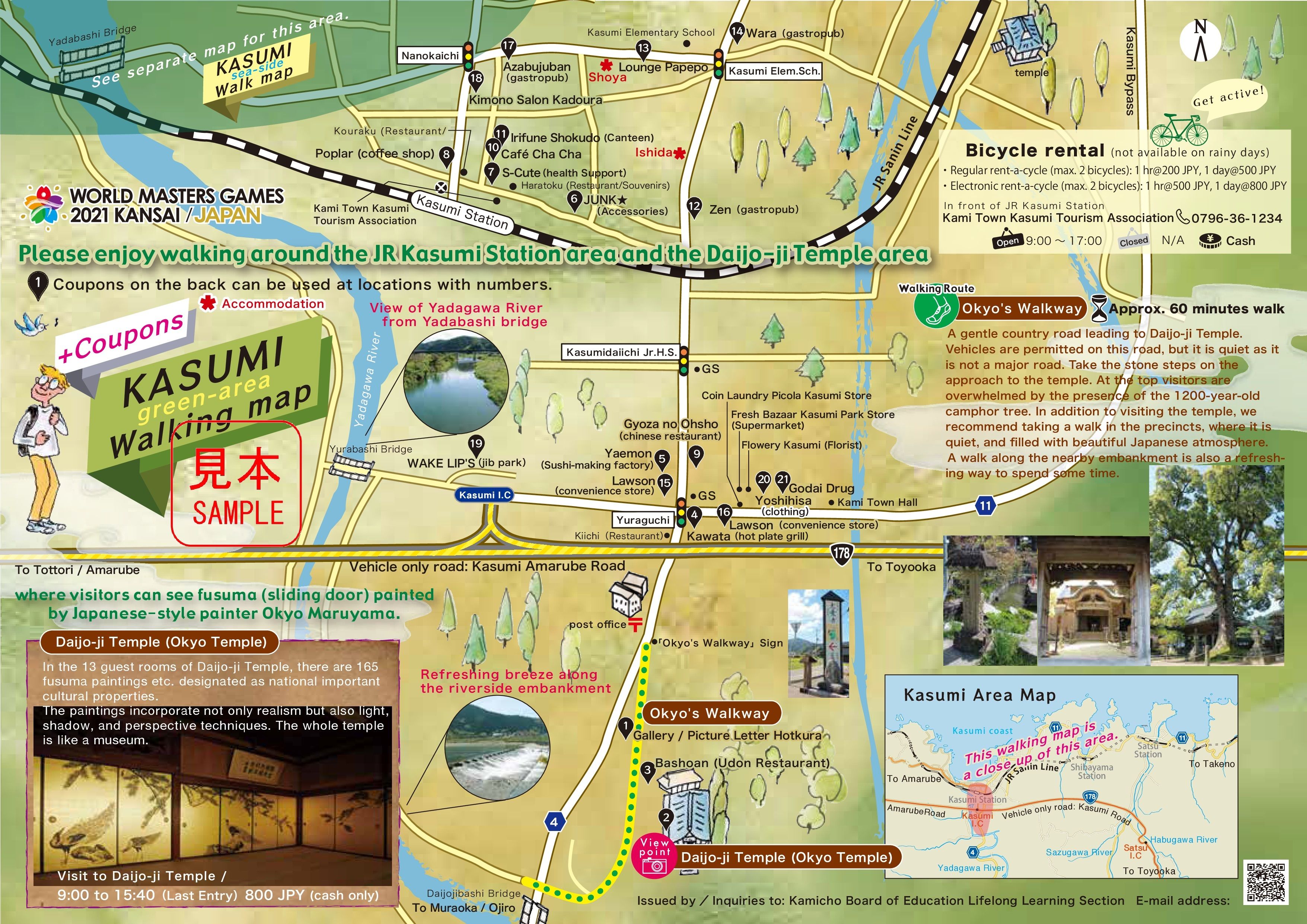
Kasumi Greenarea(Mountain side) Walking Map(Coupon)
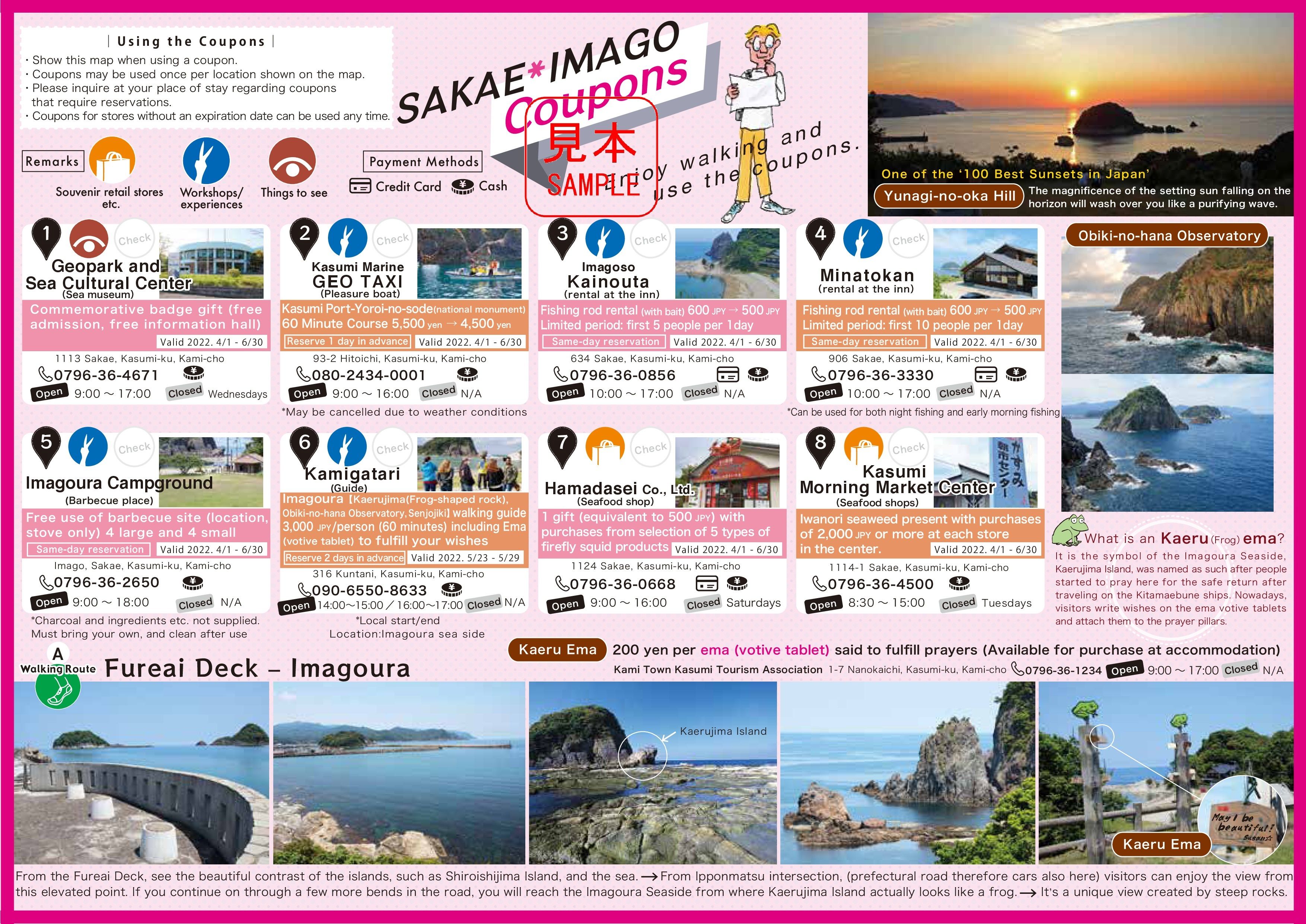
➎SAKAE・IMAGO Walking Map
Recommended points
It is a map of the place on the east side of JR Kasumi Station.
"Obiki no hana Observatory" overlooks the coastline of the precipitous cliff from a high hill, the "hill of Yunagi" where you can see the Kasumi coast, which was selected as one of the "100 best sunsets in Japan".
There is a huge frog-shaped rock "Frog Island" that is a power spot.
There is also a "Geopark and Sea Culture Center" where you can enter for free and learn about the culture and history of the sea.
You can cruise the Kasumi Coast on a small fisherman's boat called the "Kasumi Marine Geotaxi".
SAKAE・IMAGO Walking Map(Map)
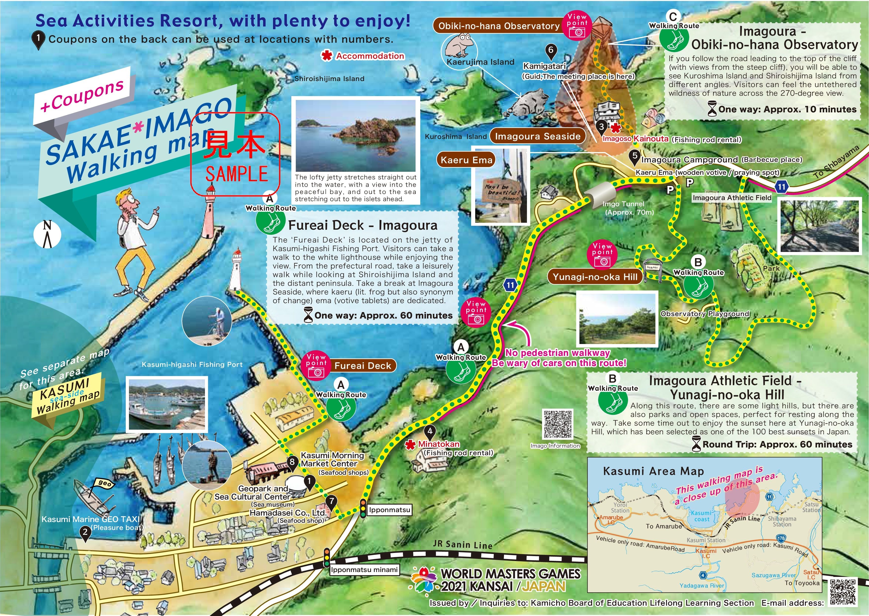
SAKAE・IMAGO Walking Map(Details of coupons and walking routes)
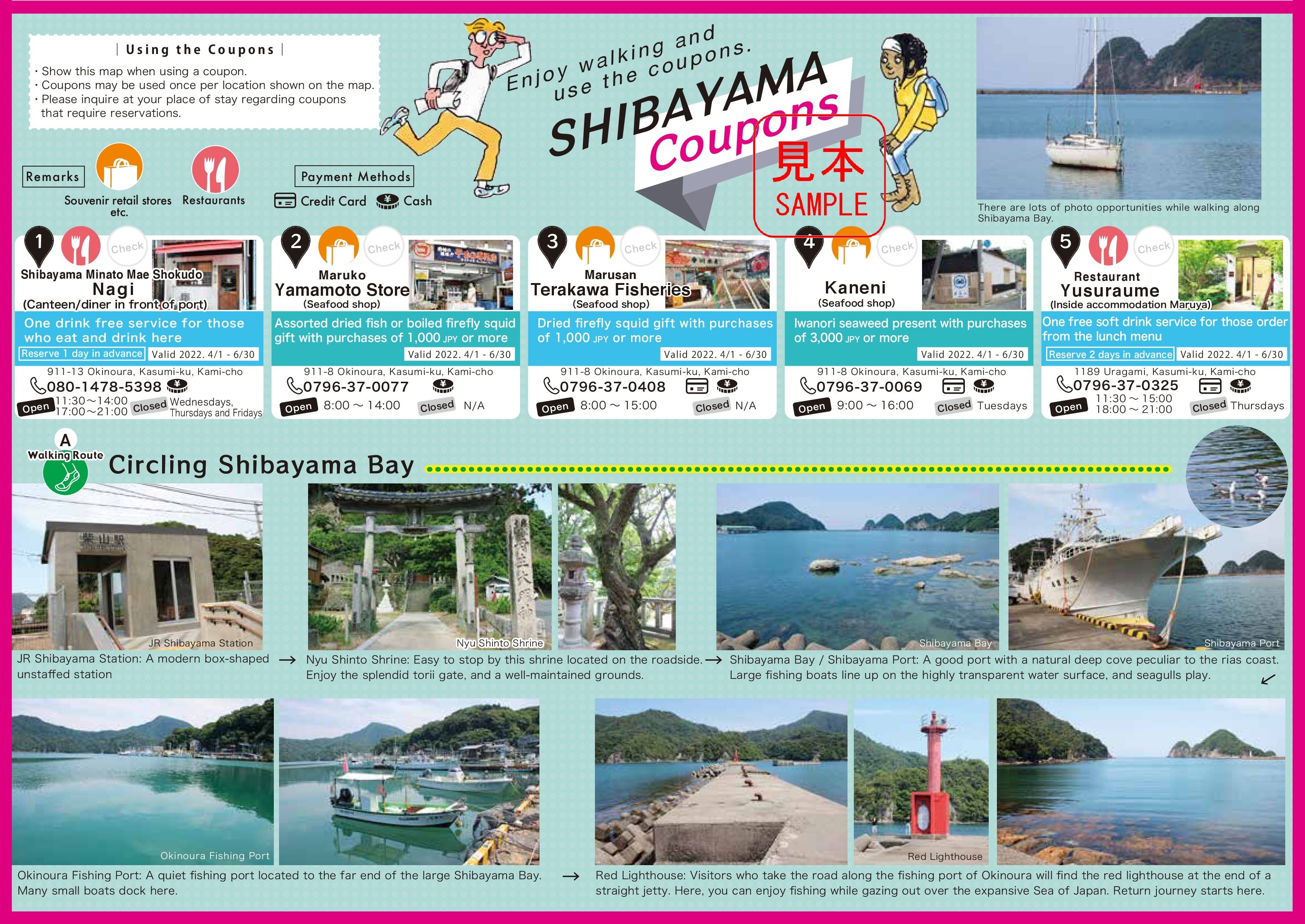
➏SHIBAYAMA Walking Map
Recommended points
This is an introduction around JR Shibayama Station.
In the quiet deep cove, there are "Shibayama Port" where large boats dock and "Okinoura fishing port" where small boats dock.
You can enjoy walking along the bay while visiting the ruins of the castle and the shrine.
Near the harbor, you can buy fresh seafood.
Shibayama Walking Map(Map)
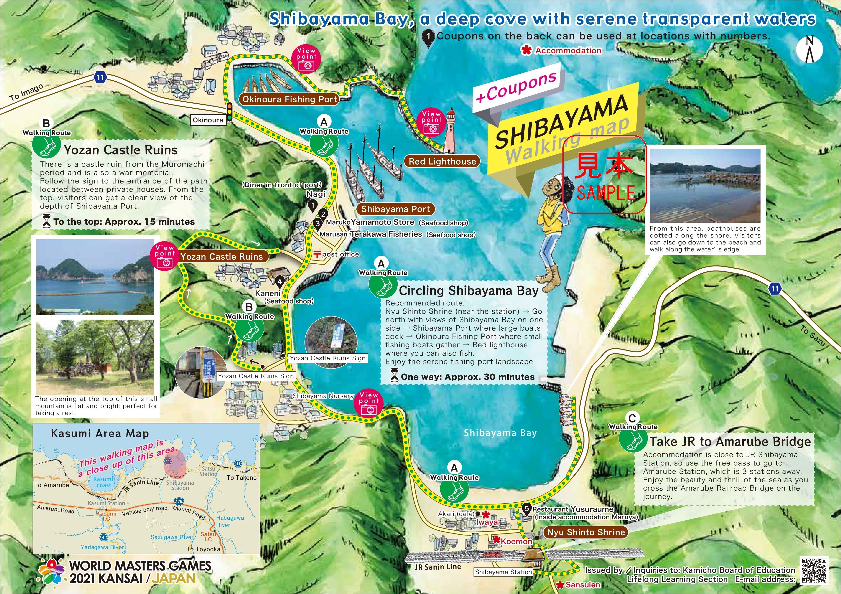
Shibayama Walking Map(Details of coupons and walking routes)
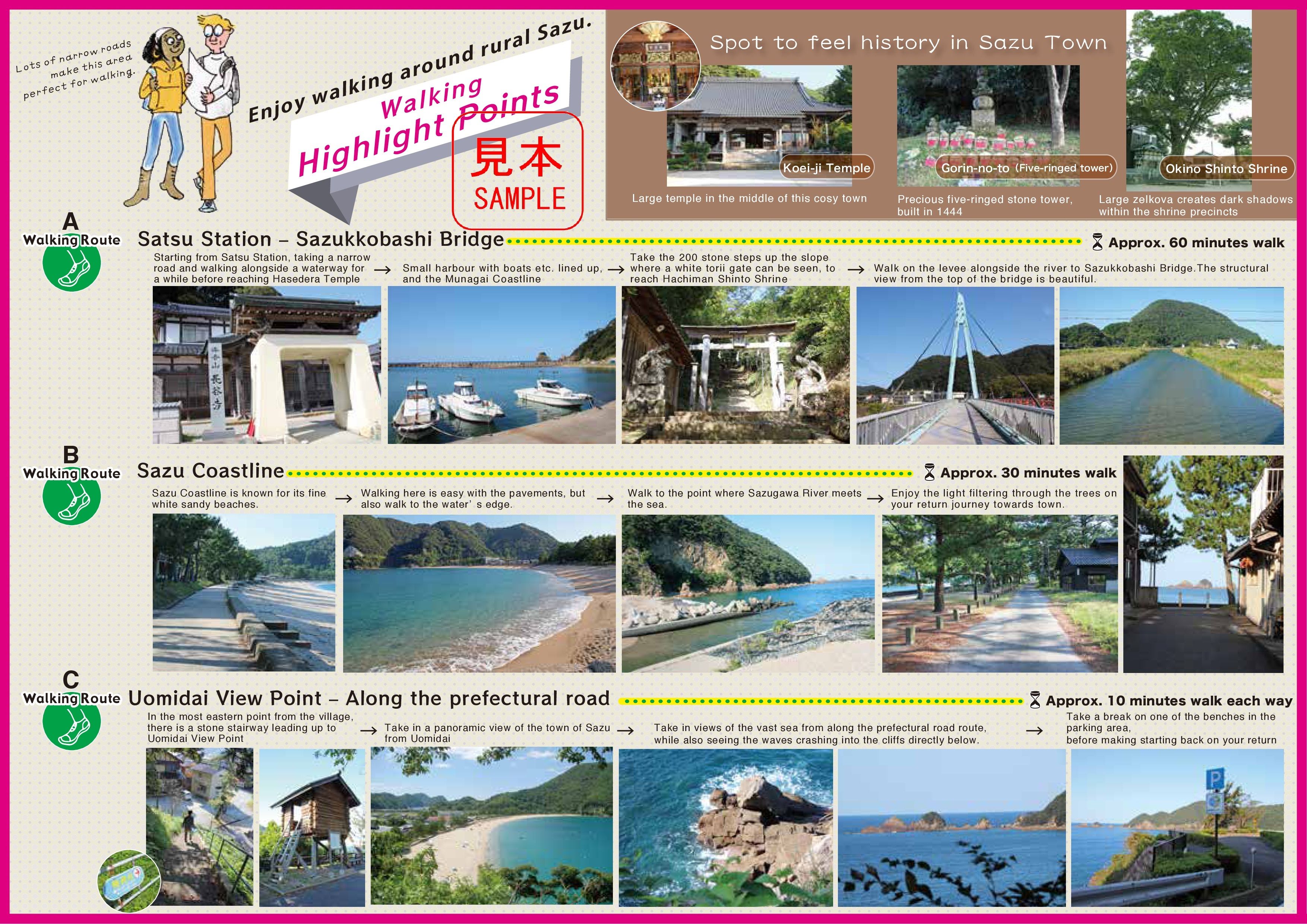
➐SAZU Walking Map
Recommended points
This is an introduction around JR Sazu Station.
You can overlook the crescent-shaped white sandy beach from "Uomidai" =view point" in the east of the town.
While listening to the sound of the waves, it may be fun to walk barefoot along the coastline or pass through the pine forest where the sunlight shines through the trees.
You can visit temples and shrines where you can feel the historical atmosphere.
Sazu Walking Map(Map)
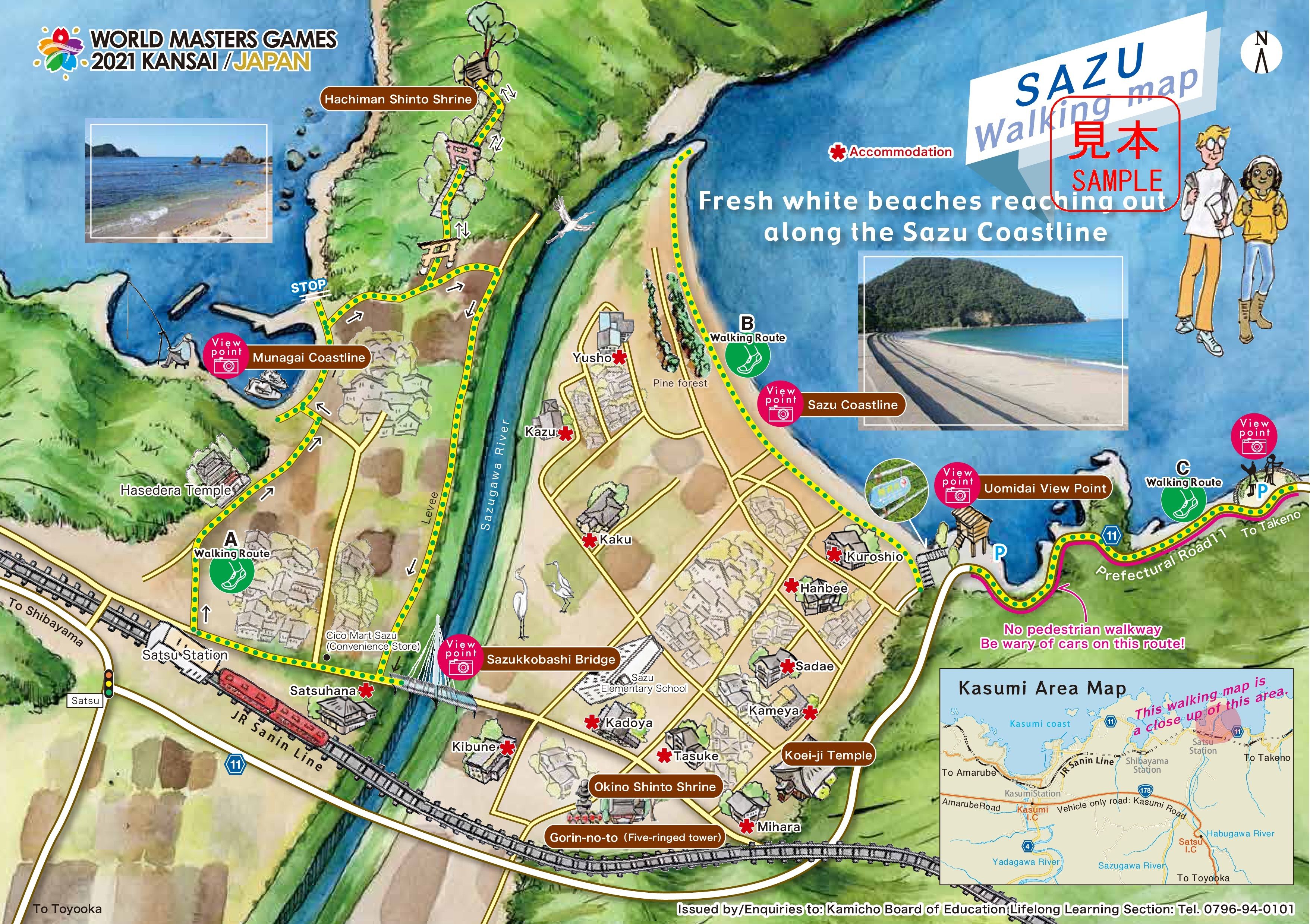
Sazu Walking Map(Details of walking routes)
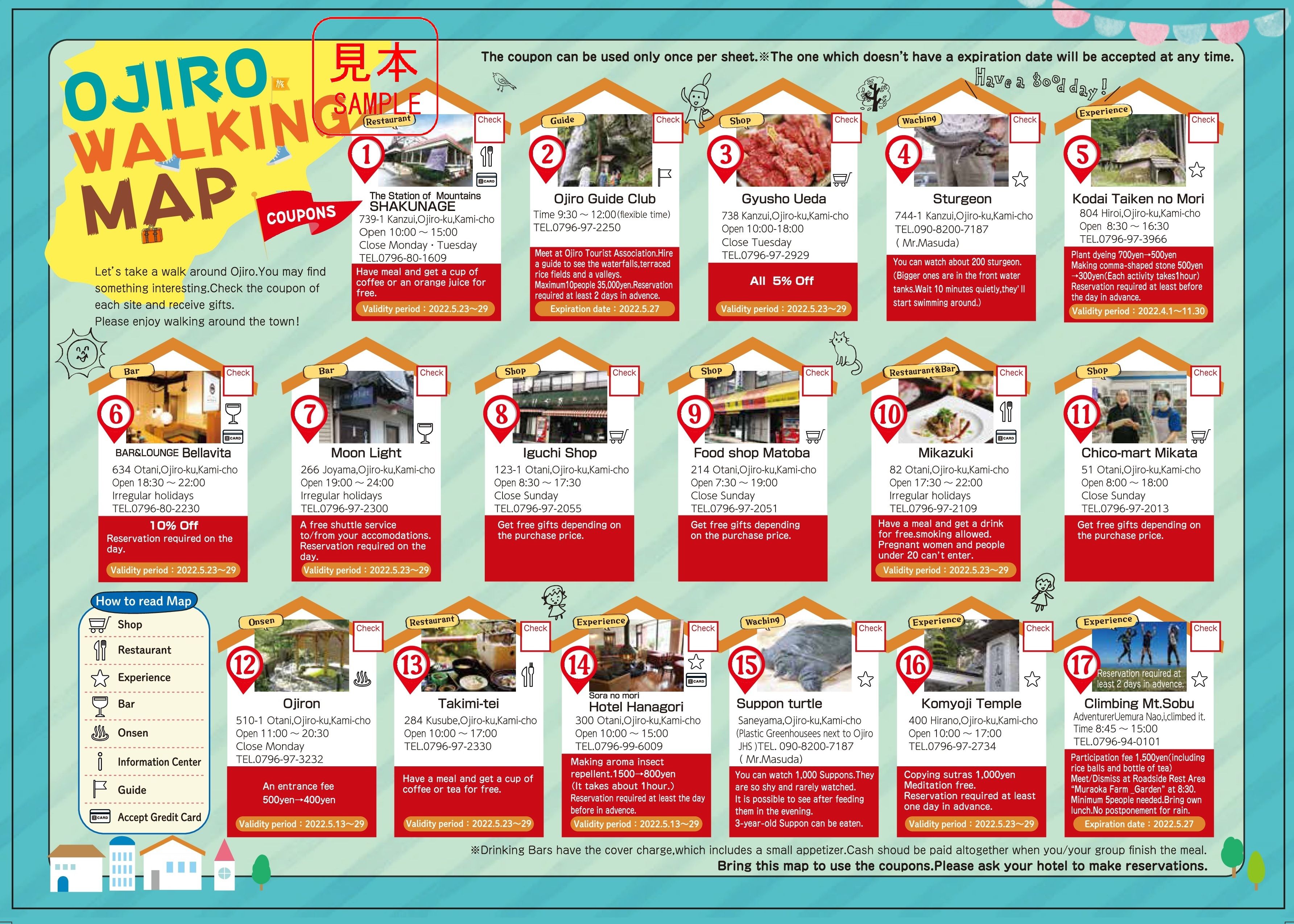
➑OJIRO Walking Map
Recommended points
Ojiro is certisfied one of Japan "most beautiful village federation".
There are "Yoshitaki Waterfall" where you can see from the back side of the waterfall, "Kusube Valley" where there are many waterfalls, and "Ueyama" rice terrace is one of the "100 best rice terraces in Japan".
Japan is famous for its delicious wagyu. Ojiro has an important role in the history of Japanese Black Cattle.
The mother cows of Japanese Black cattle "nationwide inherit 99.9% of the cattle lineage called "Tajiri-gou", and you can also see Tajima cows grazing leisurely.
Ojiro Walking Map(Map)
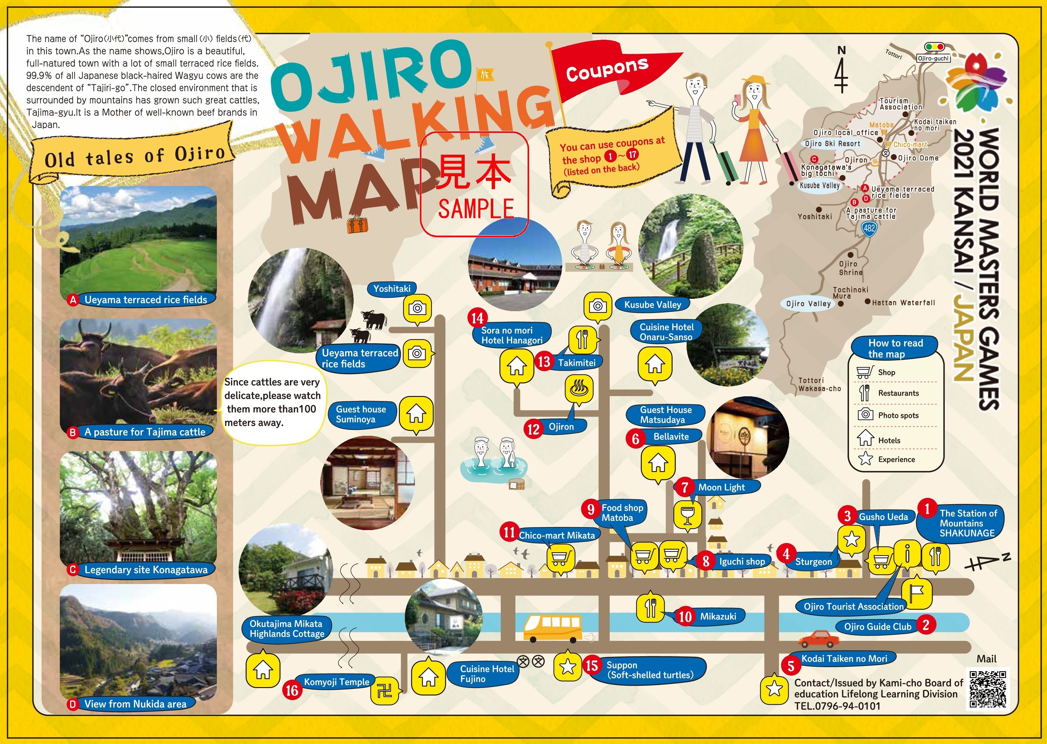
Ojiro Walking Map(Coupon)
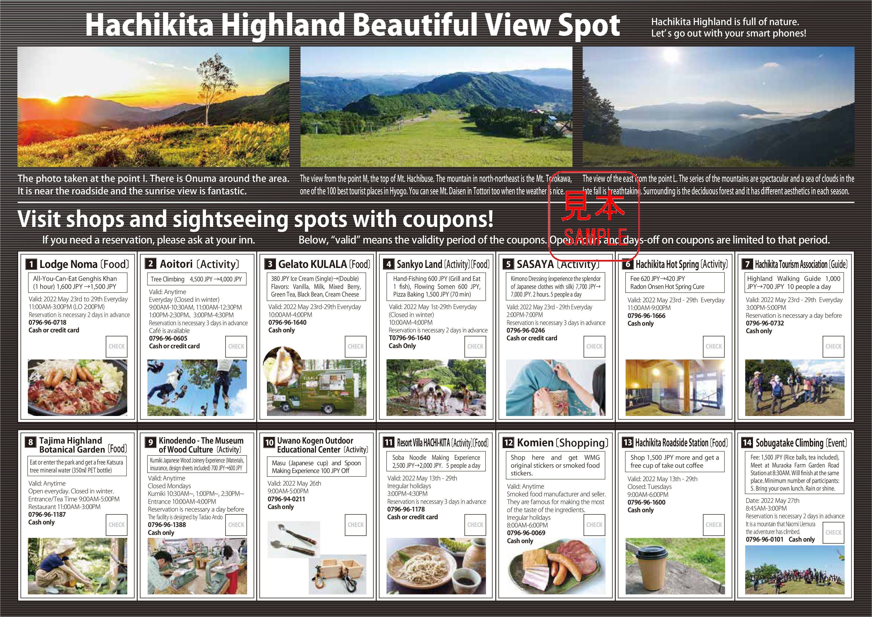
❾HACHIKITA Highland Walking Map
Recommended points
This is an introduction around the "middle the final" competition venue.
The Tajima Highland Plateau Botanical Garden, has 2000 species of native plants over 17 hectares.
Among them, the 1000-year-old giant tree "Wachi no Okatsura : big Japanese Judas trees", which stands in the bush, fascinates the viewer.
Also, Japanese Judas trees are said to collect water.
From the root of this tree, 5,000 tons of sterile water per day springs out, despite the highlands of 680 meters above sea level.
In addition, there is also a mountain climbing event to climb "Museum for Wood Culture", is one of the largest laminated wooden structures in Japan designed by Tadao Ando, and "Mt. Sobugatake" at an altitude of about 1000 meters.
Hachikita Highland Walking Map(Map)
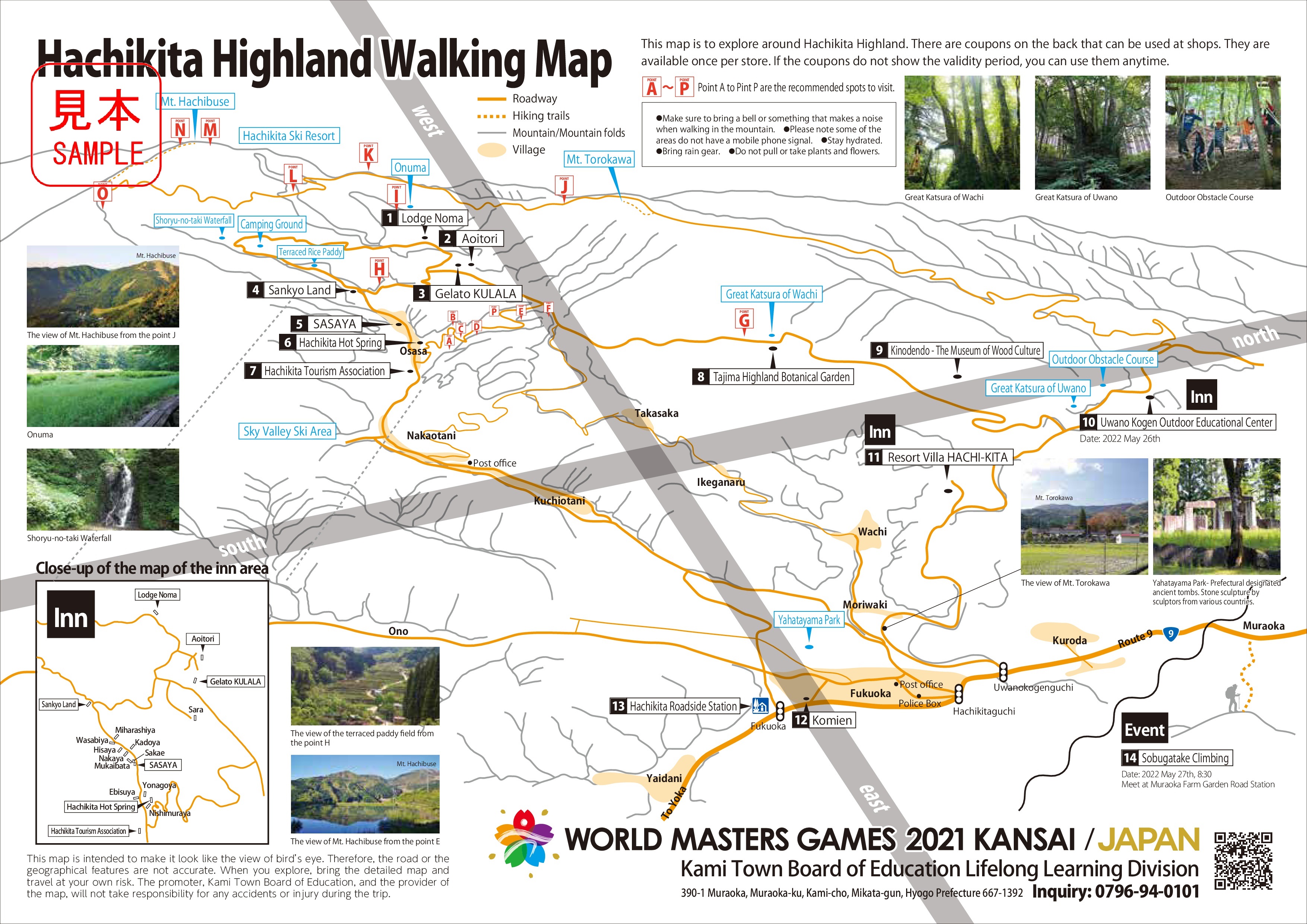
Hachikita Highland Walking Map(Details of coupons and walking routes)
ダウンロード
- Kami Town Map (Location of each map)( JPG:4MB )
- 1 AMARUBE Walking Map( PDF:5MB )
- 2 SHIMONOHAMA Walking Map( PDF:5MB )
- 3 KASUMI(Sea-side)Walking Map( PDF:5MB )
- 4 KASUMI(mountain-side)Walking Map( PDF:5MB )
- 5 SAKAE・IMAGO Walking Map( PDF:5MB )
- 6 SHIBAYAMA Walking Map( PDF:5MB )
- 7 SAZU Walking Map( PDF:5MB )
- 8 OJIRO Walking Map( PDF:4MB )
- 9 HACHIKITA Walking Map( PDF:4MB )
このページに関するお問い合わせ先
電話番号:0796-94-0101
FAX番号:0796-98-1532
